Cotahuasi: The World's Deepest Canyon That Few Foreigners Ever See
At 376 kilometers from Arequipa and more than 3,500 meters deep, Cotahuasi Canyon surpasses Colca as the deepest on Earth. There is no airport, no chain hotels. The road climbs to 4,800 meters before descending to the river. That is why it remains one of Peru's most untouched places.
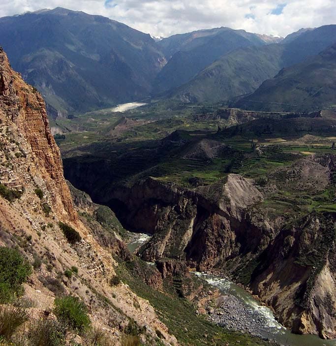
When people ask me which is the best place in Arequipa that nobody visits, I always say the same thing: Cotahuasi. Not because it is a secret — it is on every map — but because the road to get there filters out visitors with a difficulty that conventional tourist circuits cannot tolerate. Nine hours by bus from the terminal on Av. Arturo Ibáñez, a dirt section that climbs to 4,800 meters above sea level across the Pampa de Arrieros, and the final descent into a canyon 3,535 meters deep. Cotahuasi Canyon is, according to geodetic records, the deepest on the planet. It is nothing like Colca. And that is precisely its appeal.
The journey: nine hours that change your perspective
Buses to Cotahuasi typically depart from Arequipa at 6:00 p.m. — companies Reyna and Turismo Cotahuasi are the main options — and arrive at the town around dawn or shortly after. The paved road ends near Chuquibamba, about four hours from central Arequipa, where you should stop to buy food and fill a thermos: it is the last town with a decent market before entering the high plateau. From there, the road climbs between 4,000 and 4,800 meters across an altiplano of paja brava grass and wild vicuñas, with Nevado Coropuna — at 6,377 meters the sixth-highest volcano in the Andes — filling the southern horizon. On the night bus, you see little. You feel everything.
The descent into Cotahuasi is the moment the journey becomes something different. The bus begins to wind down a switchback road with the void visible on the left, the canyon walls igniting with reddish light at the first touch of dawn, and the Cotahuasi River gleaming 2,000 meters below like a silver thread. The passengers who have slept through the entire journey wake up here, without exception. No explanation necessary.
Cotahuasi is not a place you reach easily. And precisely because of that, when you arrive, it feels like yours.
Cotahuasi village: base camp at 2,680 meters
The village of Cotahuasi has about 3,000 inhabitants, a plaza with a colonial church in volcanic stone, three or four family-run guesthouses, and a market that opens at 7:00 a.m. with chicharrón de chancho and quinoa mazamorra. A reliable option is Hostal Valle Hermoso, with double rooms at S/ 50 per night including breakfast: oven bread, fresh cheese, hard-boiled egg, and brewed coffee. There is no reliable wifi in the village. Mobile data comes through the Claro signal, weak and inconsistent. That is the only legitimate complaint about the place.
The Sipia Waterfalls and the petroglyphs of Pampamarca
The most popular excursion from Cotahuasi village leads to the Sipia Waterfalls, about 12 kilometers down the canyon along the mule track that follows the river. The falls drop approximately 150 meters in free fall down a wall of black volcanic rock, and the viewing point — a natural ledge above the river — allows you to see the full arc of the water. The round trip on foot from the village covers approximately 24 kilometers and takes between six and eight hours. It is doable alone with good hiking boots and enough water, or you can hire a pack mule at the village market for about S/ 40.
Above the village, in the community of Pampamarca at 3,100 meters altitude, there is a set of pre-Inca petroglyphs — figures of serpents, camelids, and spirals carved into volcanic rock — that archaeologists from UNSA have been studying for decades without reaching a consensus on their exact dating. Access is via a dirt road 18 kilometers from Cotahuasi, reachable by mototaxi (S/ 25 round trip) or on foot in about three hours. There is no required guide, no entrance fee, no signage. Just the rocks and the silence.
The three-day trek through the canyon floor
For those with three days and trained legs, the trek through the floor of Cotahuasi Canyon — from the village down to the community of Quechualla following the river — is one of the best hiking routes in southern Peru. The first day descends from Cotahuasi (2,680 m) to Chaupo (1,800 m), crossing three suspension bridges over the river and passing through pre-Inca agricultural terraces where maize and granadilla are still grown. The second day is the most demanding: the path narrows to one meter wide above the river, climbs and drops 600 meters over 14 kilometers, and ends at Velinga, where a family offers sleeping mats for S/ 15 per person. The third day arrives at Quechualla, a village of 200 inhabitants surrounded by fruit trees — maracuyá, plantain, avocado, tumbo — in a temperate microclimate at 2,000 meters that feels impossible inside an Andean canyon.
Vous avez aimé cette histoire ?
Partagez-la avec quelqu'un qui aime Arequipa.
Vous avez votre propre histoire sur Arequipa ?
Soumettre un article →
